
 NEWParcel Spatial Check — building terms & land uses inside AND outside the town plan, for any KAEK. Unique on the market.→
All your surveying, inside your CAD.
Topo Tools is the most complete professional suite of surveying & cadastre commands — with three modules that work directly inside AutoCAD, ZWCAD, GstarCAD, BricsCAD and progeCAD on Windows.
5 CAD platformsGGRS87 / HEPOS / KAEKNative x64 & ARM64
SurveyingMaps, cadastre, points, GGRS87 coordinates and drafting.
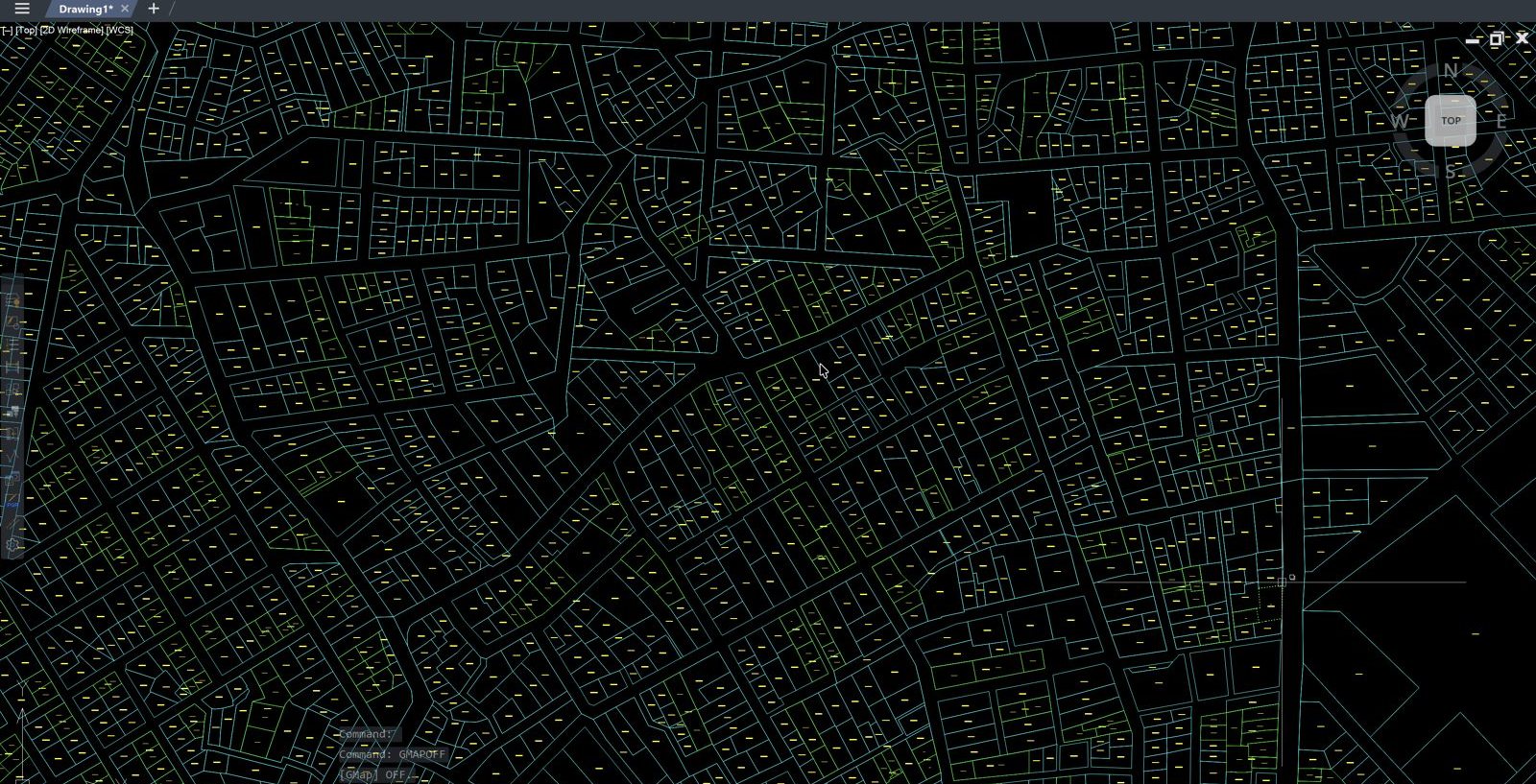 KAEK, forest maps, TEE mapCadastral data and the Unified Digital Map in the drawing.
DGM — Geometric ChangesDiagram, tables, checks, signature & ZIP.
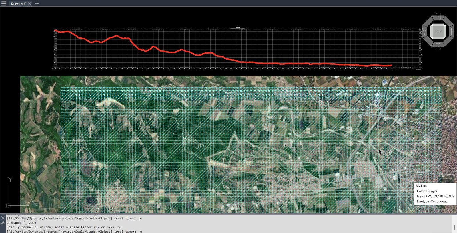
Terrain — Surfaces & VolumesTerrain models, volume calculations, profiles & cross sections.
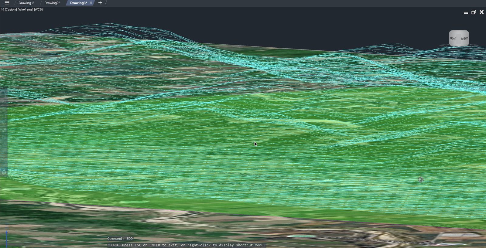
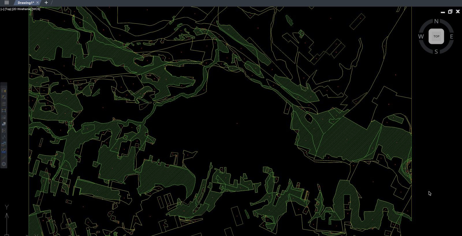
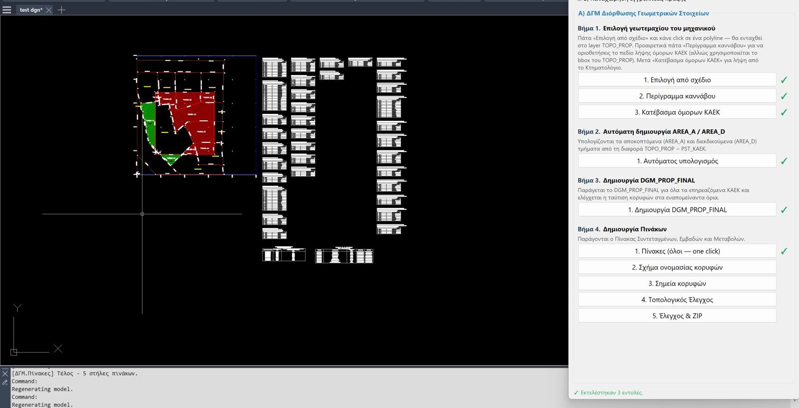
The pictures are real screenshots from CAD with Topo Tools at work. Click an image to enlarge it.
NEW · Standalone app · Windows & MacParcel Spatial Check
Complete and correct building terms and land uses — inside AND outside the town plan — for any land parcel in Greece. Something that, until now, did not exist anywhere.
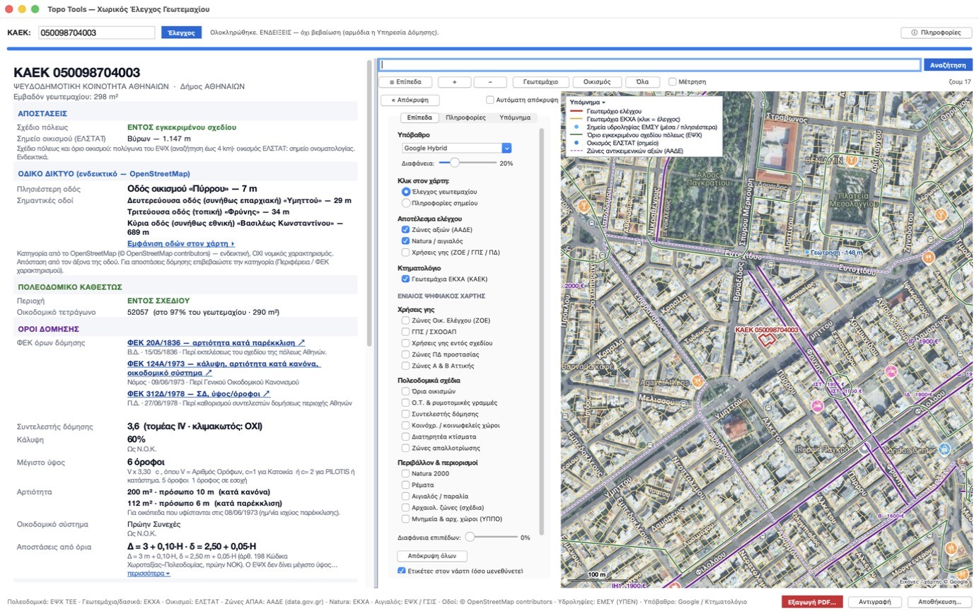
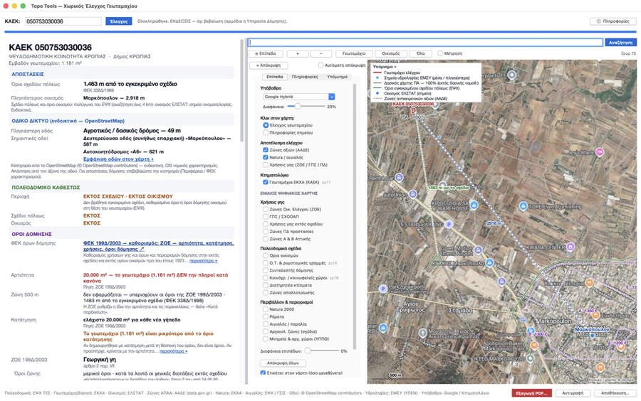
Enter the KAEK — or click on the map — and the app queries the TEE Unified Digital Map, the Hellenic Cadastre, the forest maps, ELSTAT and AADE all at once. Within seconds you have a report and a map: inside or outside the town plan, distances, building terms with the FEK references, land uses, property value zone and restrictions. No CAD needed.
€250 + VAT / yearWindows & Mac
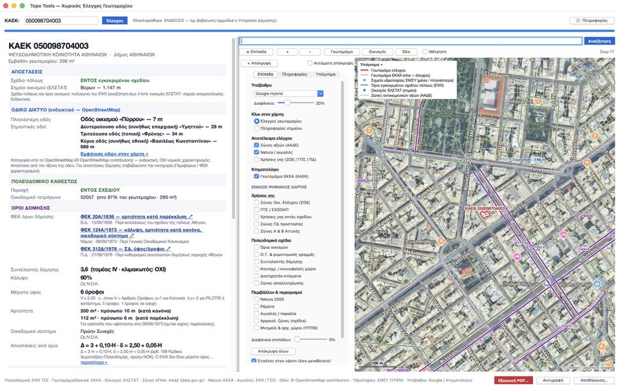
Real screenshots: building terms inside (Pagrati) and outside the plan (Mesogeia), land-use, urban-block, listed-building and Natura layers, point info (Plaka), the vector foreshore (Anavyssos), the GSIS foreshore basemap (Lagonisi) and the PDF export. Video captions are in Greek.
Complete & correct building terms and land uses — inside AND outside the town plan.
Elsewhere you see, at best, the name of the zone. Here you see exactly what is allowed: figures, conditions, exceptions and the FEK of every rule — for any land parcel, anywhere in Greece, within seconds.
What the plan sets, for this specific plot
- Building ratio — per sector
- Coverage, maximum height & storeys
- Building system and setbacks from the boundaries
- City block, public spaces, street layout
- Land uses of the plan
- The FEK of the act and of its amendments
Where until now you had to “dig through FEKs”
- Minimum plot size — by rule and by exception
- Subdivision limit — separate from plot size, as the FEK states it
- Terms and uses per ZOE / GPS / SCHOOAP / protection-decree zone
- Natura 2000 (L. 3937/2011), 500 m zone, settlement limits
- Forest map — percentage per category
- General framework of the Spatial Planning & Urban Planning Code (L. 5306/2026)
How far — and from what
From the boundary of the town plan or the settlement (inside or outside, and how many metres), from the nearest ELSTAT settlement and from the nearest road.
Inside or outside the plan
Inside the plan, inside the settlement limits or outside. With partial coverage it states x % inside / y % outside — never “unclear”.
With the FEK, in plain sight
Building ratio, coverage, height, minimum plot size, subdivision — inside and outside the plan — with the FEK of each rule one click away.
ZOE, GPS / SCHOOAP, Presidential Decrees
Residential control zones, general urban plans, in-plan land uses and protection zones — in the report and as map layers.
Official property value
The official property value zone at the parcel, with the zone boundaries drawn on the map.
Forest, Natura, foreshore, streams
Ratified or posted forest map with percentages per category, Natura 2000, foreshore, streams, registered water abstraction points (EMSY), archaeological zones and monuments.
When a spatial check pays off
- Before buying — know what you are buying, not just how many square metres.
- Before selling — have the buyer’s answers ready.
- Before an investment or development — land use, terms, restrictions.
- When preparing a contract — a first technical check of the property.
- Before a design or permit — so the work starts from the right data.
Offer the check as a service
More and more clients ask for a spatial check before a purchase or a design. With the app you deliver it in minutes — and it opens the way to the next surveying or planning assignment.
- Unlimited parcel checks with one annual license
- A ready PDF report with map, legend and FEK references — to send to your client
- The same logic as the check inside Topo Tools for CAD
How it works — 5 steps
Already working in CAD?
The Spatial Check can also be added to Topo Tools as an optional upgrade: activated with a key, inside the program you already have, only if you want it. In CAD it also imports the FEK diagrams and the building-terms table into the drawing.
The application interface and reports are in Greek; it covers land parcels in Greece.
The most modern surveying suite on the market
Topo Tools is the newest, most modern and fastest surveying suite on the Greek market. Built from the ground up with today's technology, it installs inside your CAD and adds its own ribbon with surveying, cadastre and earthworks tools — it is not a separate program. You work in the environment you already know, with your data georeferenced in GGRS87.
It brings dozens of unique features you won't find anywhere else: live maps inside the drawing, georeferencing of Google imagery directly in HEPOS (not only in GGRS87), Hellenic Cadastre orthophotos online for all of Greece, automatic Geometric Change Diagrams and volume calculations with professional reports.
It consists of three independent modules — Surveying, DGM and Terrain — licensed separately but sharing the same logic and the same coordinate systems. Built for the Greek reality: KAEK, forest maps (ratified & posted), GGRS87/HATT/TM3, the TEE Unified Digital Map — with a Greek interface and support.
- Runs on AutoCAD, ZWCAD, GstarCAD, BricsCAD & progeCAD
- Native for Windows x64 & ARM64 — no emulation
- 120+ commands in a single ribbon
- Online license check — offline for up to 7 days
- Automatic version updates
Runs directly inside the CAD you already use.
Why Topo Tools — built to save you time
Six reasons it stands apart from generic tools or manual workflows.
Newest & most modern
Designed from the ground up with today's technology — native for Windows x64 & ARM64, no emulation, with continuous automatic updates.
The fastest on the market
Optimised for speed: imports of millions of points & triangles and instant response where other programs lag or freeze.
Unique features
Dozens of capabilities that no other program on the market has — live maps, HEPOS, Hellenic Cadastre orthophotos online, automatic DGMs.
Inside your CAD
No external program — its own ribbon & commands in the environment you already use every day.
Built for the Greek market
KAEK, forest maps, GGRS87/HATT, DGM, TEE digital map — all built for Greek data.
Three modules, one logic
Shared coordinate systems & data. Combine them freely or take just one.
Native speed
Builds for x64 & ARM64 with no emulation — makes full use of your machine.
Continuous updates
Online check & one-click installation of new versions, directly from CAD.
Secure licensing
Signed license per module, with an online check at every start-up and offline work for up to 7 days (grace period).
Surveying — your everyday work
Bring maps, orthophotos and cadastral data into the drawing, work with GGRS87 coordinates and finish the drafting — all georeferenced, with no external programs.
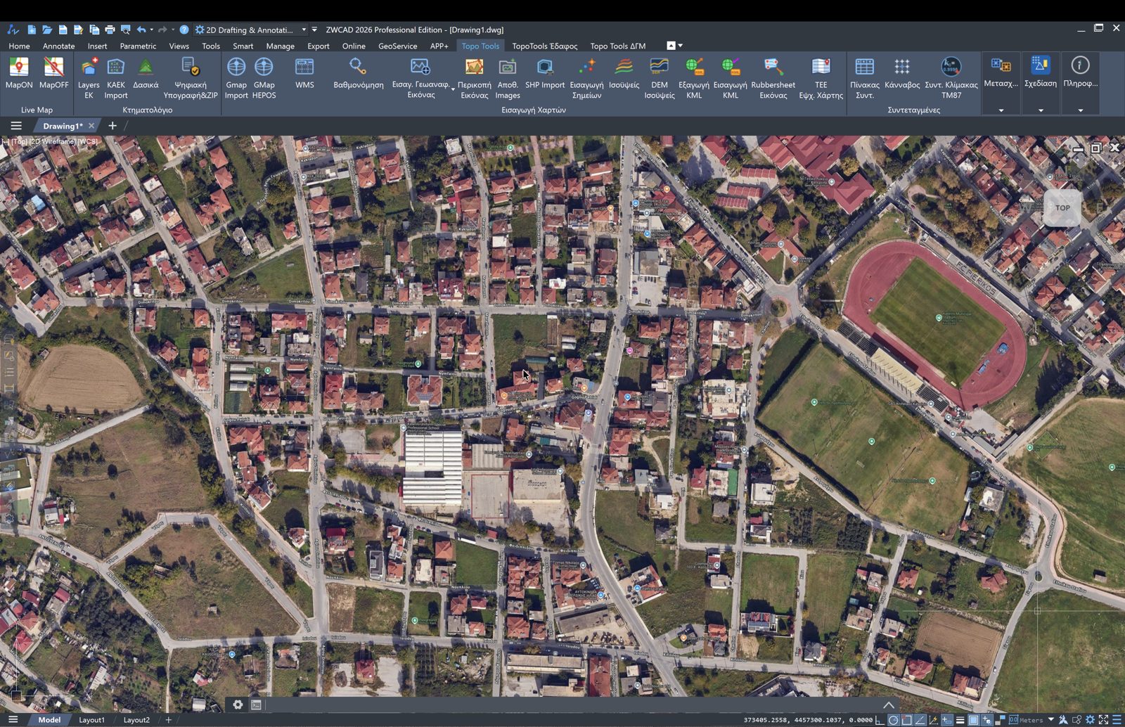

«Topo Tools» tab: Live Map, Cadastre, Map Import, Coordinates, Transformations, Drafting, Info. Click the image to enlarge it.
All the commands at a glance
What each command of the Surveying module does.
| Command | What it does |
|---|---|
| Cadastre & maps | |
 KAEK parcelsKAEK_IMPORT · KAEK | Download & insert KAEK parcels from the Hellenic Cadastre, georeferenced — including exclusive uses (vertical properties). |
 Live mapGMAPON · GMAPOFF | Live satellite background or orthophoto that refreshes on every zoom/pan. |
 Google image in GGRS87IMPORTGMAP · IGMAP | Import a georeferenced Google image in GGRS87. |
Google image in HEPOSIMPORTGMAP_HEPOS · IGMAPHEPOS | Import a Google image directly into the HEPOS system. |
 Hellenic Cadastre orthophotosIMPORTWMS · IWMS | Hellenic Cadastre orthophotos (WMS) across Greece. |
 TEE Unified Digital MapTT_SDIGMAP | TEE maps & diagrams (Unified Digital Map). |
 Forest mapsDASIKA | Import forest maps — forest area polygons with labels. |
| Data & points | |
 ShapefilesIMPORTSHP | Import georeferenced shapefiles (.shp). |
 KML / KMZIMPORTKML · EXPORTKML | Import/export KML/KMZ (Google Earth). |
 Point importIMPORTPOINTS | Import points from a file (code/elevation). |
 ContoursCONTOURS | Contours from a point cloud. |
 DEM contoursDEM_CONTOURS | Contours from a digital terrain model (DEM). |
| Coordinates | |
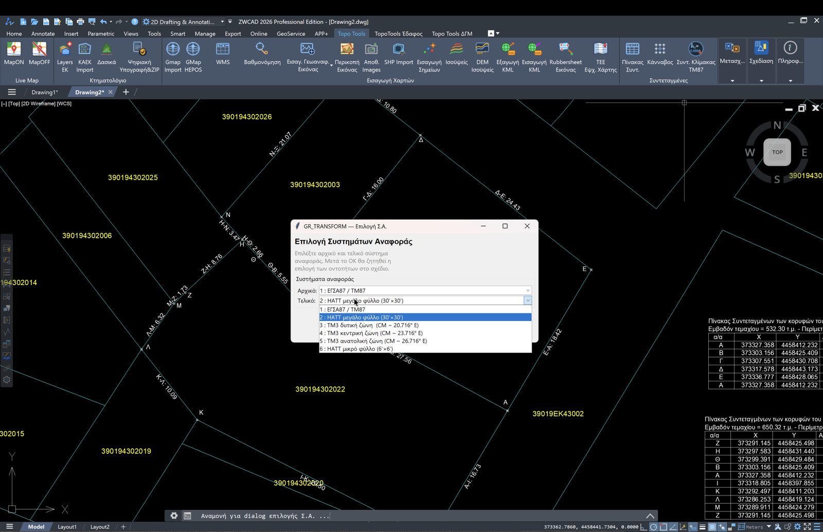
 TransformationsGRT · GRTSEL | Coordinate transformations: GGRS87 ↔ HATT ↔ TM3 ↔ WGS84. |
 TM87 / HATTTM87 · TM87SF | TM87 tools and HATT sheet selection. |
 GridGRIDCREATE | Create a coordinate grid with labels. |
| Images & raster | |
 Image georeferencingRUBBERSHEET · GEOREF | Image georeferencing with control points (rubber sheet). |
 Raster croppingIMGCROP · ICROP | Raster cropping that keeps the georeference. |
 Image exportIMGEXPORT · IEXP | Image export of a drawing area. |
| Drafting | |
 Multi-purpose surveying toolTPSM · TOPOSYNT_MULTI | Multi-purpose surveying tool. |
 Drafting aidsDRAWINGAID · DAID | Drafting aids & drawing settings. |
Things only Topo Tools does
Capabilities you won't find in any other surveying program on the market.
Google → HEPOS, not only GGRS87
Brings georeferenced Google imagery directly into the HEPOS system — not just GGRS87 (EPSG:2100) — for substantially better positional accuracy.
Hellenic Cadastre orthophotos, everywhere in Greece
Live import of Hellenic Cadastre orthophotos with flawless georeferencing across Greece — in the right place, without the 1–2 metre offsets that often occur with other solutions.
KAEK + exclusive uses (vertical properties)
We don't just bring KAEK parcels · we also bring the exclusive uses — vertical properties — with the correct structure.
TEE Unified Digital Map — Vector & Raster automatically
Automatically brings vector data and digital diagrams (raster) from the TEE Unified Digital Map, georeferenced and ready inside the drawing — effortlessly, without leaving the software, visiting another website or downloading files (JSON etc.), as other solutions require.
The whole country in seconds — Raster & Vector
With the TT_SDIGMAP command you connect directly to the TEE Unified Digital Map and bring into CAD digital diagrams (Raster) and vector data (Vector), georeferenced and ready — for any area of Greece, with no manual alignment.
Raster digital diagrams
Scanned surveys & diagrams (Government Gazette, planning acts) come in with one click — automatic georeferencing in the right place, with no manual rubber-sheeting.
Vector data
Boundaries, street layouts, diagrams and geometries arrive as real vector objects — editable, on proper layers and in GGRS87.
Speed across Greece
No area left uncovered: from the most remote countryside to the city centre, the import takes seconds and is ready to work with immediately.
KAEK import
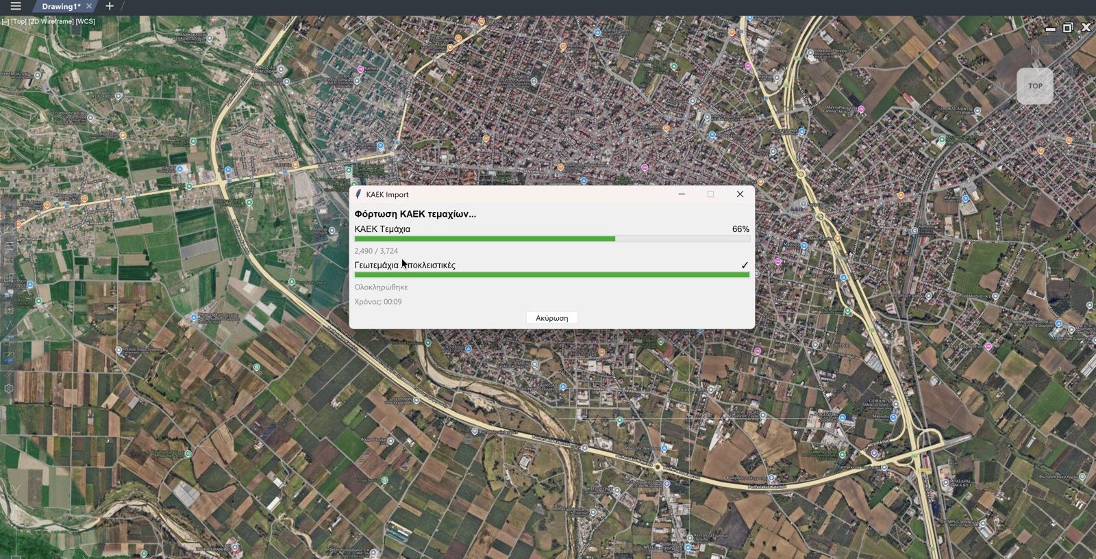
KAEK import over the live Hellenic Cadastre orthophoto, with a progress indicator.
KAEK boundaries
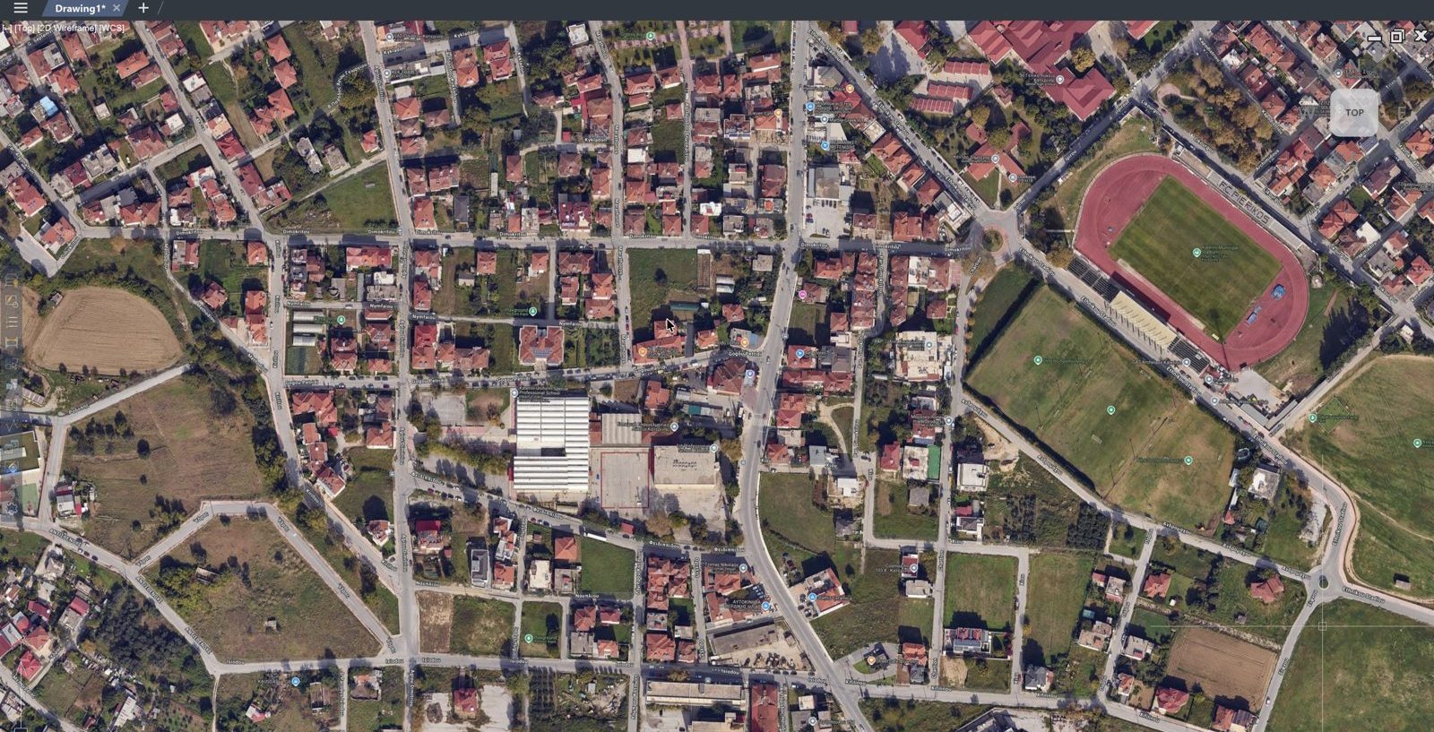
KAEK cadastral boundaries as vectors, georeferenced in GGRS87.
Forest maps
Forest maps with labels inside each polygon.
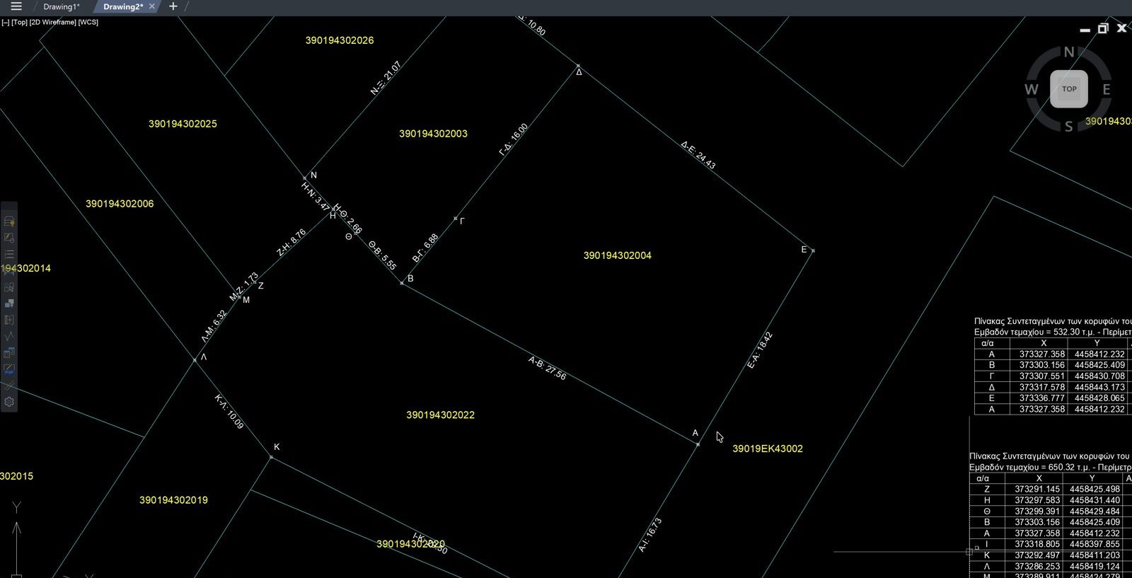
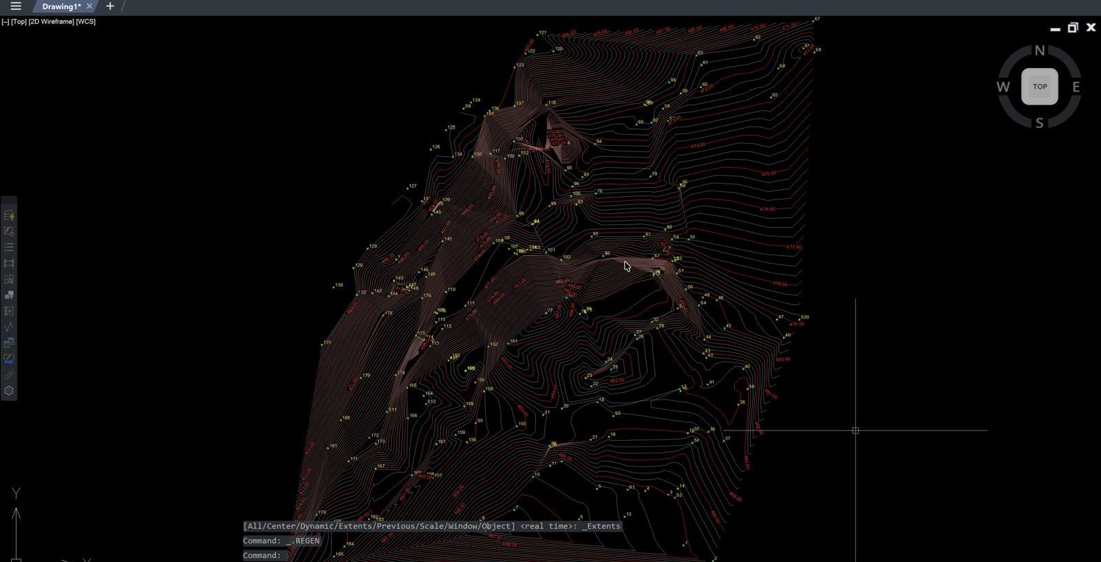
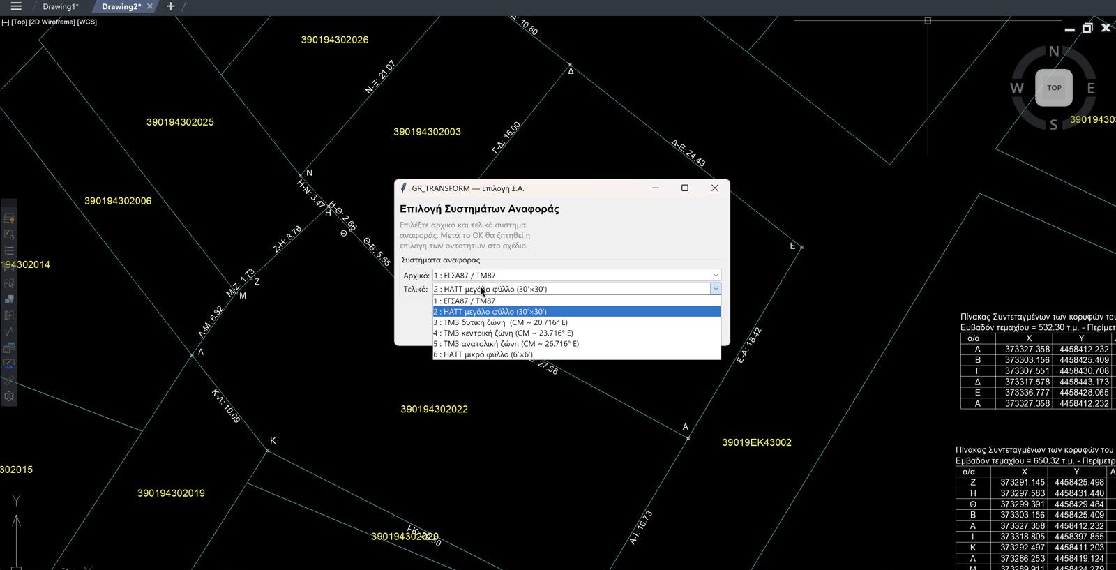
What you can do
The core module covers the whole surveying workflow: backgrounds and cadastral data inside the drawing, point and contour management, conversions between all Greek projection systems, and drafting tools for fast delivery.
Maps & backgrounds
- Live Google map (real-time zoom/pan)
- Hellenic Cadastre WMS orthophoto & HEPOS
- Georeferencing, calibration, cropping & rubber-sheeting
Cadastre
- KAEK import with labels inside the polygon
- Forest maps & TEE Unified Digital Map
- Digital signature & ready-made ZIP (PDF)
Data & points
- Point import & automatic contours
- Import SHP · Import/Export KML & KMZ
- Drafting aids, text & layers
Coordinates & delivery
- GGRS87 / TM87, HATT (387+), TM3, WGS84
- High-accuracy two-way transformations
- Vertex numbering & grid
- Export of tables & coordinate files
- Georeferenced deliverables ready for submission
Workflow — 5 steps
Geometric Change Diagrams
Automated DGM production from digitising to signing: diagram, tables, validity checks and a submission-ready package — with minimal manual work.
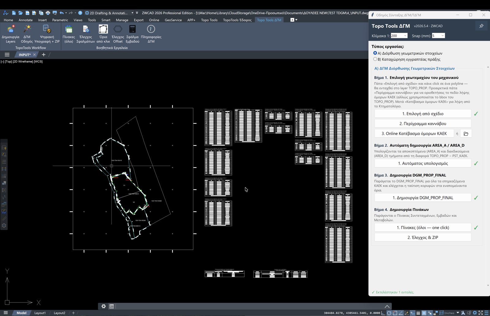
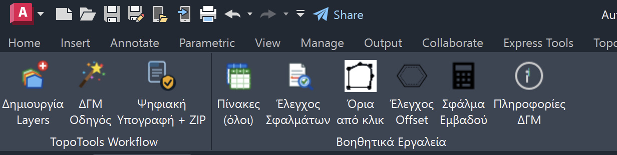
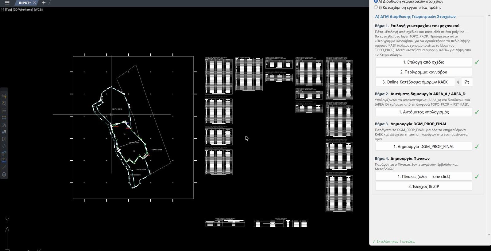
«Topo Tools DGM» tab: Workflow (Layers, Wizard, Digital Signature + ZIP) & Helper Tools (Tables, Checks, Errors, Areas).
The fastest & easiest DGM on the market
Fewer clicks, fewer mistakes, ready for submission — by a huge margin.
Always-On Wizard — step by step, for every type of DGM
The only and first program with a permanent Always-On Wizard that guides you step by step so you can complete every type of Geometric Change Diagram with incredible speed and ease — something you won't find in any other program on the market.
From digitising to DGM in a few clicks
The wizard takes you step by step — subdivision, vertical property creation, merging — with automatic snapping of lines to boundaries.
Automatic tables & diagrams
Change, coordinate and area tables are generated automatically — not by hand.
Validity checks + ready for submission
Built-in completeness/topology checks and signing — a submission-ready package.
Preparing a DGM step by step
Watch the workflow for preparing a Geometric Change Diagram inside CAD — from the input data to the geometry correction.
Not playing here? (local preview) — open it on YouTube.
Commands — DGM
What each command of the Geometric Change Diagrams module does.
| Command | What it does |
|---|---|
| Wizard & drafting | |
 DGM wizardDGM_WIZARD | The DGM wizard — step by step: subdivision, vertical property creation, merging. |
 Engineer's polygonsDGM_SELECT_TOPO | Selects the engineer's polygons to be processed. |
 Subdivision/vertical linesDGM_LINEXM_SESSION | Draws subdivision/vertical property lines with automatic boundary checking. |
 Vertex numberingDGM_VERTEX_NAMING · DGM_VERTNUM | Vertex numbering & naming. |
 Title & declarationDGM_TITLE · DGM_DECL | Diagram title & declaration/solemn declaration. |
| Tables | |
 All tablesDGM_TABLES_ALL · DGM_TABLE | Generates all DGM tables automatically. |
CoordinatesDGM_COORDFILE | Vertex coordinate table/file. |
 AreasDGM_AREATBL | Area table. |
 DistancesDGM_DISTTBL | Side distance table. |
 ChangesDGM_METAB | Change table (initial → final state). |
| Checks & submission | |
 Validity checkDGM_CHECK | Validity check — completeness & topology (validator). |
 CorrectionDGM_DIORTHOSI | Correction of geometry & discontinuities. |
 Errors / accuracyDGM_ERRTBL | Error/accuracy table. |
 Export & clean-upDGM_EXPORT · DGM_CLEAN | Export & clean-up of the finished DGM. |
 Signature & ZIPDIAG_SignAndZip | Digital signature & compression (zip) — ready for submission. |
Severed & claimed parts
Severed (green) & claimed (red) parts, with automatic tables and automatic area calculation.
What you can do
The DGM module handles the whole preparation of the Geometric Change Diagram: it automatically detects severed and claimed parts, produces the diagram and all tables, and runs validity checks so the deliverable goes through without surprises.
Diagram & tables
- Automatic production of the DGM, title & declaration
- Change, coordinate, distance & area tables
- Area correction & error table
Wizard & splitting
- Guided step-by-step workflow (wizard)
- Automatic parcel splitting
- Severed / claimed parts & joint lawsuit
Checks & submission
- Topology & completeness checks
- Detection of gaps, overlaps & duplicate vertices
- Digital signature & ready-made submission ZIP
Workflow — 5 steps
Terrain — Surfaces & Volumes
Build digital terrain models from any source, generate contours, calculate cut/fill volumes with professional reports, and produce longitudinal profiles & cross sections.

«TopoTools Terrain» tab: Import (DEM, SRTM, LAS/LAZ, points), Surfaces, Longitudinal Profiles, Cross Sections, Help.
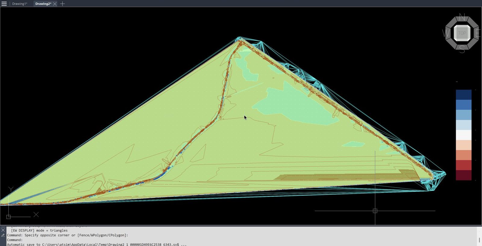
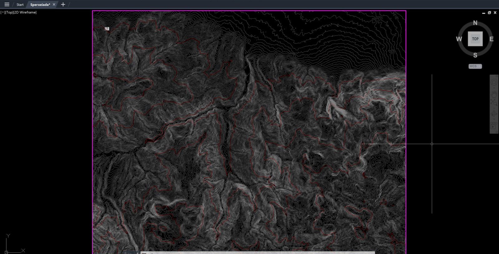
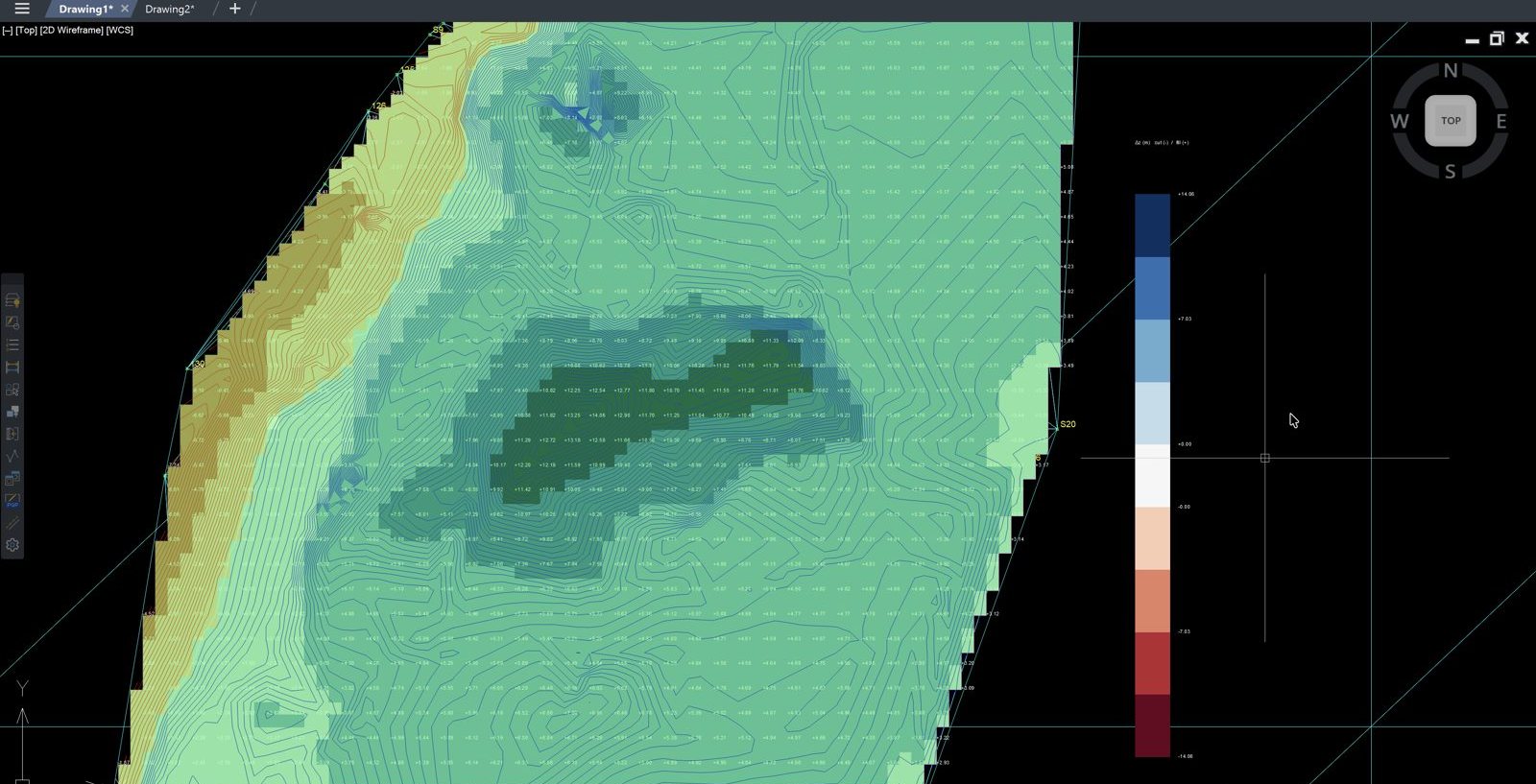
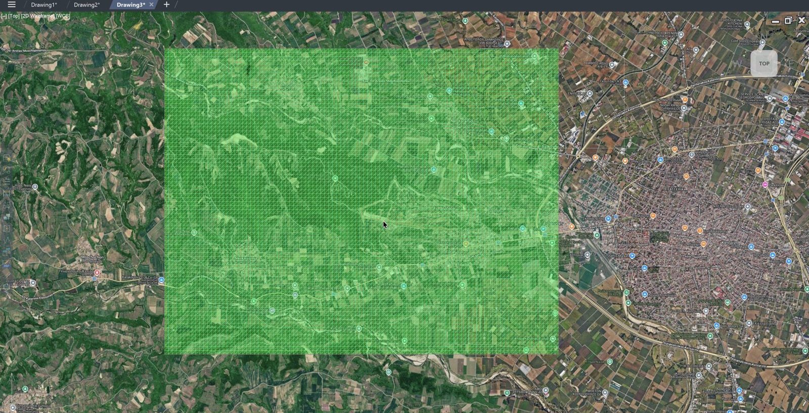
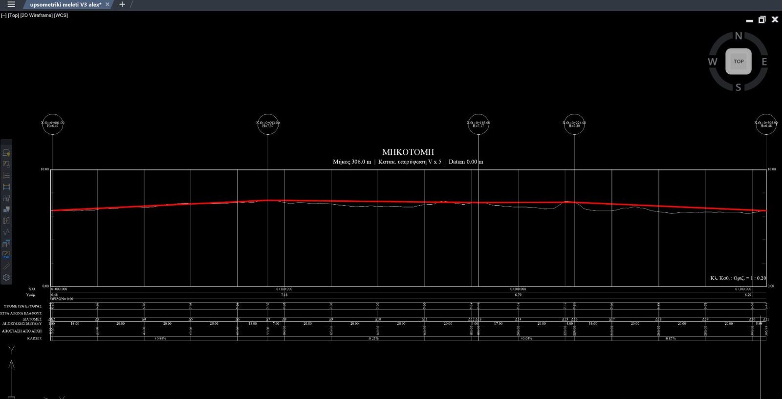
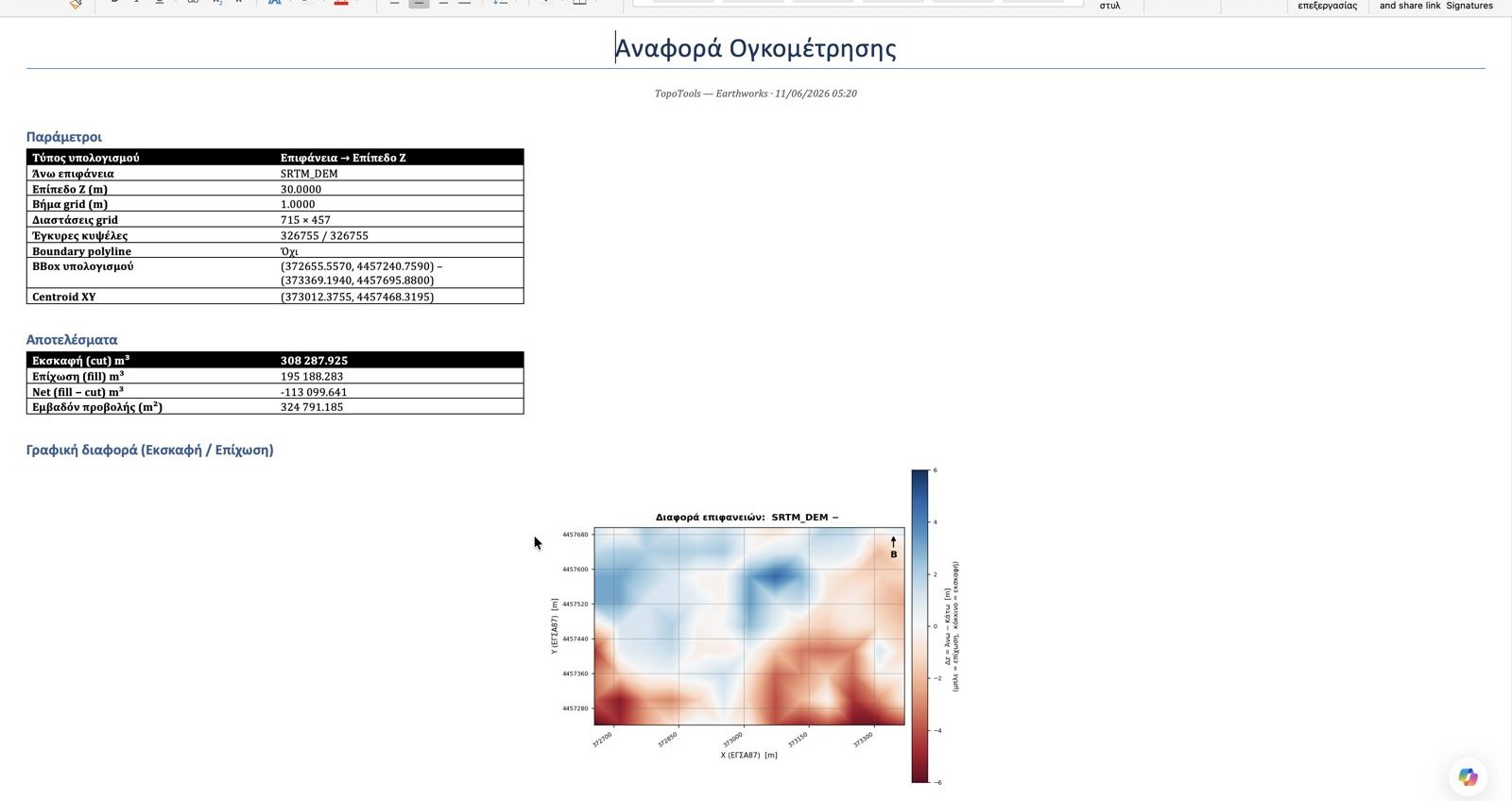
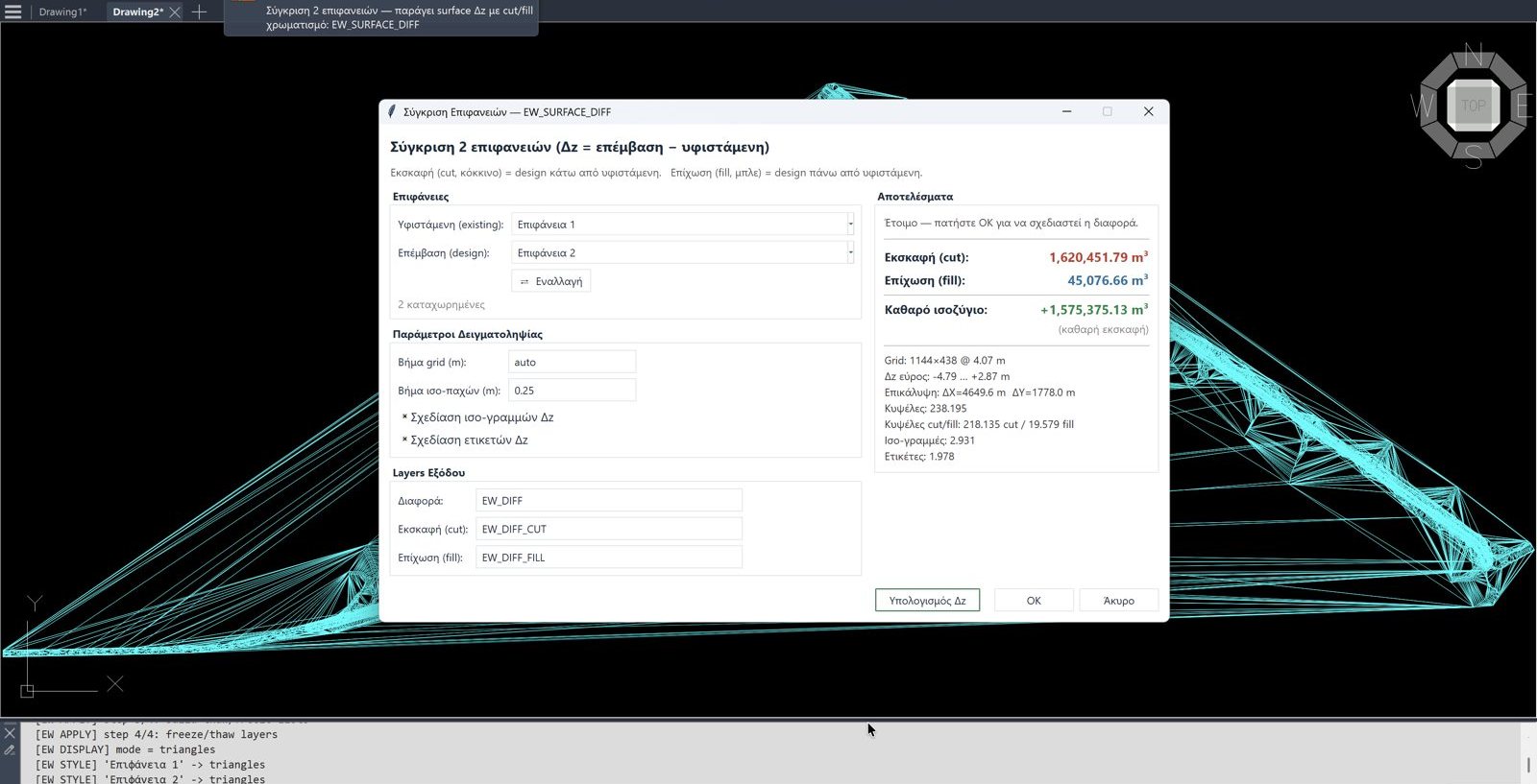
Real screenshots from the Terrain tools. Click an image to enlarge it.
A complete earthworks workflow — inside CAD
Everything you would need Civil 3D or an external GIS for, inside your own CAD.
The whole earthworks workflow inside CAD
Surfaces, volumes, longitudinal profiles, elevation maps and 3D — without Civil 3D or external software.
LiDAR · SRTM · DEM
Downloads SRTM/DEM elevation data online and imports LiDAR (LAS/LAZ) point clouds — TINs of millions of triangles, fast.
Cut/fill volumes + Word report
Surface comparison with a colour cut/fill heatmap and an automatic, ready-made Word report.
Workflow — 5 steps
 ImportPoints / DEM / SRTM / LAZ.
 SurfaceCreate & manage the TIN.
 AnalysisContours, display & comparison.
 VolumesCut/fill volumes + heatmap.
 SectionsProfiles/sections & reports.
Commands — Terrain
What each command of the Terrain module does.
| Command | What it does |
|---|---|
| Import & surfaces | |
Surface from pointsEW_SURFACE · EWSURF | Create a surface (TIN) from points. |
 Point importEW_IMPORTPOINTS · EWIPTS | Import points to create a surface. |
 DEM importEW_DEM_IMPORT · EWDEMIMP | Import a DEM & create a surface (millions of triangles). |
 SRTM onlineEW_SRTM_IMPORT · EWSRTM | Download SRTM elevation data online. |
 LiDAR (LAS/LAZ)EW_LAZ_IMPORT · EWLAZIMP | Import LiDAR (LAS/LAZ) point clouds. |
 Surface import / exportEW_SURF_IMPORT · EW_SURF_EXPORT | Import/export of surfaces (LandXML etc.). |
| Management & analysis | |
 Surface managerEW_SURFACES · EWSURFMGR | Surface manager (colour, layer, display). |
 Surface editingEW_SURFACE_EDIT · EWSEDIT | Surface editing — add/delete triangles. |
 Display modeEW_SURF_DISPLAY · EWSDISP | Display mode: triangles / outline / fill / 3D. |
ContoursEW_CONTOURS · EWCTR | Contours from a surface. |
Elevation mapEW_HEIGHTMAP_REGEN | Elevation map (heightmap) with colour rendering. |
 Surface comparisonEW_SURFACE_DIFF · EWSDIFF | Compare two surfaces — elevation difference / heatmap. |
| Volumes & sections | |
Volume calculationEW_VOLUME · EWVOL | Cut/fill volume calculation with a cut/fill graphic & Word report. |
 Longitudinal profilesEW_PROFILE · EWPROF | Longitudinal profiles along an alignment. |
Cross sectionsEW_SECTION · EWSEC | Cross sections (from an alignment or existing lines). |
 Design grade lineEW_REDLINE · EWRED | Design grade line — design line for volumes. |
What you can do
The Terrain module turns data of any format into a usable digital terrain model and covers the whole earthworks chain: contours, surface comparisons, volume calculations with reports, and longitudinal profiles/cross sections for project designs.
Surface creation
- From a point file or points in the drawing
- From DEM, SRTM/Copernicus & LAS/LAZ (LiDAR)
- Management, editing & precise clipping
Analysis
- Coloured contours & editing
- Surface comparison & elevation map
- Display modes: triangles / perimeter / heightmap
Volumes & sections
- Cut/fill volumes with a difference heatmap
- Volume report in Word / PDF
- Longitudinal profiles, design grade line & cross sections (also from existing lines)
What each module includes
Some capabilities (e.g. contours, digital signature) are available in more than one module.
| Feature | Surveying | DGM | Terrain |
|---|---|---|---|
| Live map & WMS orthophoto | ✓ | — | — |
| Cadastre (KAEK, forest maps) | ✓ | — | — |
| Import SHP / KML-KMZ / points | ✓ | — | — |
| Coordinates & transformations (GGRS87 / HATT) | ✓ | — | — |
| Geometric Change Diagrams | — | ✓ | — |
| Cadastre tables & checks | — | ✓ | — |
| Severed / claimed parts / joint lawsuit | — | ✓ | — |
| Digital signature & submission ZIP | ✓ | ✓ | — |
| Surfaces (TIN) from DEM / SRTM / LAZ / points | — | — | ✓ |
| Contours | ✓ | — | ✓ |
| Cut/fill volumes & reports | — | — | ✓ |
| Longitudinal profiles & cross sections | — | — | ✓ |
| Elevation map (heightmap) | — | — | ✓ |
Correctly georeferenced, always
Full support for the Greek projection systems with high-accuracy two-way transformations — to and from GGRS87. Available in all modules.
Topo Tools in one video
A look at the workflow inside CAD — from data import to the final result.
See all the videos on our channel
Not playing here? (e.g. in a local preview) — open it directly on YouTube.
Pay only for what you need
Each module is licensed separately — or get all three in one bundle. License per workstation, with support & updates in Greek and English.
| Module | Includes | Price | |
|---|---|---|---|
| Surveying | Cadastre, KAEK, forest maps, live map, orthophotos, TEE. | €500+ VAT | Get a license |
| DGM | Geometric Change Diagrams, automatic tables, checks, ready-made ZIP. | €500+ VAT | Get a license |
| Terrain | Surfaces, contours, cut/fill volumes, longitudinal profiles & cross sections. | €500+ VAT | Get a license |
| Full suite Best value | All three modules together — Surveying + DGM + Terrain. Save €300 compared with buying separately. | €1,200+ VAT | Get a license |
| Parcel Spatial Check NEW | Complete building terms & land uses inside and outside the plan for any KAEK. Standalone app for Windows & Mac, no CAD. | €250+ VAT / year | Request it |

Free trial
Request the trial version for your platform and we will email it to you — so you can evaluate it in the environment you already work in.
Request the trial versionOnline license (no USB token), on every computer of the license holder. Multi-seat discounts apply — ask for a quote.
Custom features & software on demand
We develop custom features and build software on demand for the specific needs of a public authority, organisation or company — from new CAD commands and automations to dedicated applications for your workflow. Prices by arrangement.
Flexible licensing, per module
You pay only for what you need. The license is checked online at every start-up and keeps working offline for up to 7 days (grace period).
Per module
Separate license for Surveying, DGM and Terrain. If you only license one, the others simply stay inactive — no problem at all.
Online & offline
Online check at every start-up, with offline work for up to 7 days (grace period) and automatic updates.
Version control
The license sets the maximum supported CAD & Topo Tools version, with clear notice to the user — everything is shown under «Info».
System requirements
- Operating system
- Windows 10 / 11x64 & ARM64 native
- CAD platform
- AutoCAD (+ Civil 3D · Map 3D) · ZWCAD · GstarCAD · BricsCAD · progeCADFull CAD edition (not Light/Standard).
- Integration
- Ribbon & commandsno external application
- Updates
- Automaticonline version check
- Internet
- For the license check, live maps, orthophotos and updates. Offline for up to 7 days.
Working on a Mac?
Topo Tools is also available for macOS — the first suite of surveying commands for iCADMac, native on Apple Silicon.
Try it in your own CAD
Request the trial version for your platform and we will email it to you — so you can evaluate it in the environment you already work in.
Requires Windows 10/11 and a full CAD edition (not Light/Standard). Native x64 & ARM64.
Try it or get a license
Tell us which CAD you use and which modules you are interested in — we will send you a trial link and licensing information.
- Trial use before purchase
- License per module — pay for what you need
- Support & updates in Greek and English
Or email us directly — one click opens a ready-made message:
topotools@topotools.xyzTry it in your own CAD
Trial use before purchase · License per module — pay for what you need
Everything you want to know
Does it work with the CAD I already have?
Yes. It integrates directly into AutoCAD (as well as Civil 3D / Map 3D), ZWCAD, GstarCAD, BricsCAD and progeCAD on Windows, with its own ribbon and commands — no external application.
What is the Parcel Spatial Check?
A standalone application for Windows and Mac — no CAD needed. Enter the KAEK (or click on the map) and within seconds you get a report and a map: inside or outside the town plan, distances to the plan and the settlement, complete building terms and land uses — inside AND outside the plan with the Government Gazette (FEK) references, official property value zone and restrictions (forest map, Natura, foreshore, streams). License €250 + VAT per year. Learn more.
Can I buy just one module?
Absolutely. Each module is licensed separately. If you only license one, the others simply stay inactive and do not affect anything.
Is there a Mac version?
Yes. Topo Tools is also available for macOS — the first suite of specialised surveying commands for iCADMac / IntelliCAD, native on Apple Silicon (M1/M2/M3). See topotoolsmac.gr.
Do I need a permanent internet connection?
Not permanent. The license is checked online at every start-up; if there is no connection at that moment, the program keeps working offline for a limited grace period (up to 7 days from the last successful check). So you can work in the field or without internet for days — as long as you reconnect within the grace period. Internet is also needed for live maps, orthophotos and updates.
Does it support the Greek coordinate systems?
Yes — GGRS87/TM87, TM3 (Transverse Mercator 3°), HATT (387+ sheets), HEPOS and WGS84, with high-accuracy two-way transformations.
Does it produce a DGM ready for submission?
The DGM module automates the production of diagrams & tables, runs topology/completeness checks and creates a digitally signed ZIP package ready for submission.
Can you tailor the software to our needs?
Yes. We develop custom features and software on demand for public authorities, organisations and companies, with prices by arrangement. Contact us to describe what you need.
Contact us
Questions about the tools, licences or a multi-seat quote? Write to us and we will get back to you.
